| Home | About Us | Email Us | Find It | What's New | Back | Next | |
| VIEWER MESSAGES | ||
|
| MISCELLANEOUS | ||||
|
||||
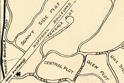 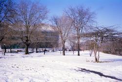 Pictures dated c. 1908 and 2003
Click images to enlarge |
Maple Grove Park
When it first opened, Maple Grove Cemetery included two plots named "Sunny Side" and "North Border" located on the other side of Queens Boulevard (then called Hoffman Boulevard) next to the present day Criminal Courthouse. No one had yet been buried there when the City acquired the land in the early 1950's in conjunction with the construction of the Van Wyck Expressway. On July 21, 1997, New York City Parks Commissioner Stern officially christened it "Maple Grove Park".
Source:
- Circa 1908 map courtesy of R. Billard