| Home | About Us | Email Us | Find It | What's New | Back | Next | |
| VIEWER MESSAGES | ||
|
| MISCELLANEOUS | ||||
|
||||
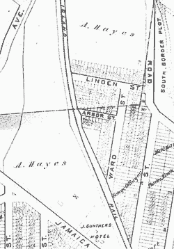 Map dated c.1900
Click images to enlarge |
Hayestown
At the turn of the century, the area between Lefferts Boulevard and Maple Grove Cemetery was called Hayestown after its owner, Ambrose Hayes. Hayes ran a general store near today's Metropolitan Avenue and Cuthbert Road. His property was not included in Albon Man's 1868 purchase of Richmond Hill, but after Hayes' death in 1911, the Man Family acquired the land and renamed it East Richmond Hill. Yet, for decades afterwards, residents still referred to the place as Hayestown.
Source:
- Map from the Lucy Ballenas Collection courtesy of Carl Ballenas
Reference:
- Undated Manuscript by William Kroos, p. 57