| Home | About Us | Email Us | Find It | What's New | Back | Next | |
| VIEWER MESSAGES | ||
|
| MISCELLANEOUS | ||||
|
||||
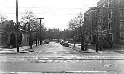 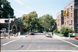 Pictures dated c. 1940 and 2001
Click image to enlarge |
116th Street
"Major thoroughfares, railroad tracks, and preserved green space carve Kew Gardens into a series of relatively distinct districts. Between Lefferts Boulevard, the railroad tracks, Union Turnpike, Forest Park, and Metropolitan Avenue, streets with names like Abingdon, Audley, Beverly and Onslow climb in a sort of curving grid up to the heights of Forest Park at the top of the terminal moraine. The winding, tree-lined streets, seem to intersect at less-than-regular angles and then curve out of view, luring the traveler up the hill to see what lies beyond."
Sources:
- Quote from "Inside Kew Gardens", by Michael Winkleman (METROPOLIS Oct. 1982)
- Circa 1940 picture from the Lucy Ballenas Collection courtesy of Carl Ballenas