 | |||||||
| Home | About Us | Email Us | Find It | What's New | Back | Next | |
| VIEWER MESSAGES | ||
|
| MISCELLANEOUS | ||||
|
||||
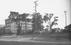
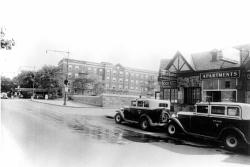
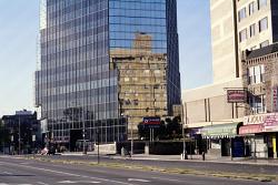
   Pictures dated c. 1923, 1930 and 2002
Click image to enlarge |
At Union Turnpike
Source:
- 1920 and 1923 pictures courtesy of the Queens Borough Public Library, Long Island Division, Illustrations Collection - Kew Gardens
In the first photograph, the building is the old Kew Gardens Inn which, years later, was turned into the Kew Gardens General Hospital. Notice that the cross street, Union Turnpike, is a dirt road lined with small houses - a far cry from the row of apartment buildings that stands there today.
In the second photograph, the dirt road is gone and the canyon we call the Jackie Robinson Parkway (then called the Interboro) has replaced it. The Kew Gardens Inn is all that survives from the prior photograph.
By the time the third photograph was taken, the Kew Gardens Inn had become the Kew Gardens Hotel and then the Kew Gardens General Hospital before being torn down and replaced with the Crossroads office tower. Not a trace of the 1923 scene remains.