| Home | Email Us | Find It | What's New | Back | Finish | ||
| VIEWER MESSAGES | ||
|
| MISCELLANEOUS | ||||
|
||||
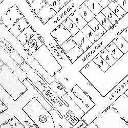 Map dated 1920
Click image to enlarge
Image enlarges to 500KB (1500 x 1131 pixels)
|
Kew Gardens
Within 10 years after the opening of the new Long Island Railroad Station, the rough terrain of North Richmond Hill had been cleared, graded, and built into the Kew Gardens housing development. This 1920 map shows a dramatic change from the 1873 map of almost 50 years earlier. In the years to come, Kew Gardens would change yet again as construction of Queens Boulevard, the Grand Central and Interborough Parkways, and more than two dozen apartment houses would transform it from a country village to an urban village.
Sources:
References:
- Barry Lewis, Kew Gardens: Urban Village in the Big City,
pp. 27 - 28, 30 - 31 (Kew Gardens Council for Recreation and the Arts 1999)