Back
Home
Email Me
About Me
Read Guestbook
Guestbook Archives
Sign Guestbook
Where Are They?
What's New
Find It
Need It
Links
Books
Your Old Photos
1920's Map
Current Map

Back | Next
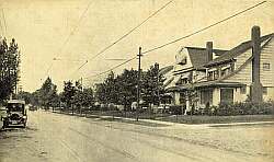
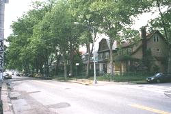
Pictures dated 1928 and 2001.
Click on images to enlarge.
From 124th Place
The view is from 124th Place (formerly, Cuthbert Place) looking west on Metropolitan Avenue toward Lefferts Boulevard which is 2 blocks away. Note the trolley tracks and overhead trolley wires in the top picture. Until the 1950's the only part of Metropolitan Avenue that was paved was that bearing the trolley tracks. The rest was dirt as you can also see from a close examination of the top picture. Sadly, the corner house was demolished shortly after the bottom picture was taken.
Sepia tone picture courtesy of Claire Levine.