Back
Home
Email Me
About Me
Read Guestbook
Guestbook Archives
Sign Guestbook
Where Are They?
What's New
Find It
Need It
Links
Books
Your Old Photos
1920's Map
Current Map

Back | Next
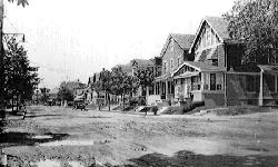
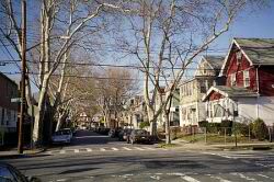
Pictures dated 1924 and 2002.
Click on images to enlarge.
124th Street
The Kew Gardens housing development which opened in 1910 comprised only the area between Lefferts Boulevard, Kew Gardens Road, Union Turnpike and Metropolitan Avenue. Surrounding areas now considered part of Kew Gardens were different communities. The top picture shows the view from today's 85th Avenue looking north on 124th Street (then called Curtis Avenue) at a time when it was considered part of Richmond Hill. Metropolitan Avenue lies one block ahead.
1924 picture courtesy of the Queens Borough Public Library, Long Island Division, Illustrations Collection - Kew Gardens.